
John Montresor c.1771
Fort Duquesne. Quebec. Fort Detroit. Lexington. Bunker Hill. Brooklyn. Brandywine and Germantown. In a time when people generally didn’t travel more than thirty miles from their homes, John Montresor, an engineer in the British Army and later Chief Engineer in America during the American War of Independence, saw more of the North American continent than many of us who live in North America have today. His career spanned three tumultuous decades, beginning in the 1750s and ending in the 1770s, and carried him into some of the defining moments of American and Canadian history. Miriam Touba writing for the New York Historical Society aptly describes his “everywhere footprints” in a very thorough and well written blog post.
John Montresor was born the 22nd of April 1736 to James Gabriel Montresor (also an engineer in the British Army) and Mary Haswell in Gibraltar. Before arriving in America with his father, he had spent some time both in Menorca and England, receiving his education there in London. It was soon after his arrival in America that he joined the disastrous expedition to Fort Duquesne, later dubbed “Braddock’s Defeat”, so beginning twenty or so years of travelling in the British Army.
Throughout the span of his travels, Montresor kept his pen and paper close, preserving his movements and escapades across the land. Despite the passing centuries, a good chunk of his writings still exist in the form of the Montresor Journals, allowing readers to take an episodic glimpse of the past in all its vivid realness. It’s in his earlier journal entries that we actually find him at the second siege of Louisbourg on Cape Breton Island in the spring and summer of 1758, serving as a practicing engineer working on the British siegeworks just outside the fortress walls. His journal entries go on to depict a very routine and ordinary 18th century-style siege, culminating in the capture of Louisbourg and the colony of Île Royale.
It’s his next journal entries, however, that peaks our interest. It begins: “Journal of a route from Louisbourg to Lake Labrador: 1759 March 27th – One officer – 26 Rangers, 3 private men of the 45th Regiment were detached from the Garrison…to proceed on an Inland Scout, directing to Lake Labrador, from thence to a Point La Jeunesse…so to cross the lake again to La Badick bearing North from thence, where there is a small straggling settlement, near the Saw Mill River, to bring in what French (Acadians) we could find inhabiting those parts.” And so Montresor sets out on this inland scout with the goal of crossing the Bras d’Or lakes (as they’re presently known), taking notes on everything he sees and allowing us to peer into the landscape and infrastructure of rural Cape Breton some 250 years ago. Unfortunately, none of the homes or graves Montresor goes on to mention on his inland scout exist today. Even the roads they walked on (except for small portions) have all been reclaimed by nature.

A small portion of the Great Mira Road (or le grand chemin de Miré) as it appears today. Constructed in the 1730s, it was in use throughout the 19th century and well into the 1900s*
The party sets out from Louisbourg on the grand chemin de Miré, or what this blog will call the Great Mira Road, a well-built road constructed in the 1730s by French engineers that ran from Louisbourg out to the Mira River, linking the many property owners in that area to the colony’s capital. This road was actually a feat unto itself, since apparently at certain points two carriages could pass each other without one having to stop and pull over – an impressive achievement in the New World at that time. They pass through an area known as Cabinet Planchi, then by “Portic’s Farm” and onward past present-day Twelve Mile Lake to Lac à Lertie, settling into a barn “which was built by Jean Lertie*, from whom the Lake is named as also the Lake adjacent to the House.” It’s sobering to imagine what life must’ve been like living fifteen-or so miles into the middle of an empty forest, your nearest neighbours living many miles in either direction.
The party is awakened the next morning by a storm, a mixture of snow and sleet, making their passage over the five feet of snow that had already fallen through the winter that much more difficult. As they continue their approach to the Mira River, Montresor describes passing through the burnt-out villages of Rouler (Rouillé according to the French) and the Village des allemands. Both villages were the ambitious plan of the Count de Raymond, Louisbourg’s eccentric governor from 1751-1753 who was determined to settle soldiers on the Mira to supply Louisbourg with grain. Some of the most questionable men from the garrison took him up on his offer, and he named the village after the French Minister of the Marine, Rouillé. Village des allemands on the other hand was settled by a group of German migrants from the Palatine and Ruhr regions of Germany, giving us an idea of Cape Breton’s diversity during this period*. It seems that both villages were burned to avoid them being used by the British during the spring of 1758. Although there is no neighbourhood that corresponds to the location of these two villages today, the modern-day French Village Lake gives us a hint as to where they were actually situated.
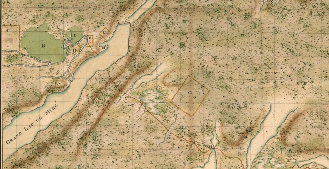
The Great Mira Road (drawn in red) in the environs of the Mira River and Salmon River c. 1735. In twenty years time, the settlements of Rouillé and Village des Allemands would develop between properties F and G. The small lake between these two properties is known today as French Village Lake.
Montresor and the scouting party then cross the frozen Mira River on foot, truly beginning their trek out of civilization and into the deep unexplored interior of Cape Breton. It’s here that they make use of another one of Count de Raymond’s ambitious plans, the chemin Raymond or Raymond’s Road, a communication road that ran close to fifteen miles from the north shore of the Mira across the Bras d’Or Mountains to the shores of the Bras d’Or lakes. Constructed at the cost of 100,000 French livres without authorization from France, in the end the real cost was most likely Raymond’s governorship. Raymond’s Road, the Rouillé Road (which ran from modern-day Baddeck to Sainte Anne’s) and a portage road cleared in Port Toulouse allowed quick communication between the three principle settlements of Cape Breton Island, but they were highly criticized at the time for being strategically flawed.
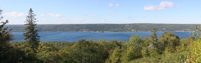
Part of the Bras d’Or lakes that Montresor’s scouting party would’ve seen from the top of the Bras d’Or mountains
Two days later, having climbed the Bras d’Or Mountains, Montresor makes record of their party standing at the summit, looking down onto the Bras d’Or lakes only a quarter of a mile away. Having stopped no doubt to rest for a bit, Montresor takes the time to mark in his journal the location of a grave they had discovered atop the summit: “Monsieur Lavu de Jambon, Engineer employed making the road to St Anns.”
Who was this engineer? It’s doubtful anyone today knows. Where is the exact location of his grave? Again, no one really can say. It’s likely that the brief notation Montresor gives us about this grave is the only record of this man’s existence we have today. This little passage in Montresor’s journal is so very interesting because it helps us grasp what happens when the human elements of a society are interrupted by upheaval. Entire lives slip through the cracks and are forgotten – entire histories disappear.
In the end, John Montresor never did complete his inland scout to the Saw Mill River – the ice had thawed too much to be able to safely cross the lakes, and so he returned to Louisbourg. It could be said that the most successful thing he did during this week of travelling to the interior of Cape Breton Island was leave for us a small glimpse into a community whose stories people can no longer tell. Much like Montresor and his scouting party, it was in that era that many of the cultural histories of the French in Île Royale came to a dead end.
* No doubt this is the property that was owned by Joseph Lartigue, a member of Louisbourg’s operating council and judge in Louisbourg’s only bailiff court.
*Correction (2 May 2021) – changed from “large parts of it were still in use up to the 1960s, linking the modern towns of Louisbourg and Gabarus.”
For more reading, see “Report on Eighteenth-Century Roads and Properties in Preparation for the Fleur-de-Lys Highway” by Kenneth Donovan – parkscanadahistory.com/publications/louisbourg/fleur-de-lis-trail-aris.pdf
* The book Aspects of Louisbourg says: “Aside from French, which was obviously the dominant language, Basque, Breton, German, Swiss German, Spanish, English and perhaps Irish, Provençal and Micmac were sometimes spoken in Louisbourg.”
